Top Stories
Severe Thunderstorm Warnings Rock Pennsylvania – What You Need to Know

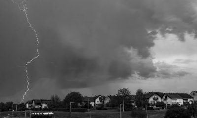
A powerful weather system is currently sweeping across the state of Pennsylvania, triggering severe thunderstorm warnings and watches in multiple counties, including Lancaster, York, Philadelphia, Chester, and Montgomery. Residents are being urged to stay indoors and prepare for strong winds, hail, and the potential for tornado activity.
This dangerous outbreak of storms is the result of high heat and humidity clashing with an incoming cold front—conditions that commonly lead to summer thunderstorms in the Mid-Atlantic region.
⚠️ Storm Warnings for Lancaster and York Counties
As of the afternoon of June 19, 2025, the National Weather Service (NWS) has issued a severe thunderstorm warning for both Lancaster and southeastern York counties. The storm is moving east at approximately 25 mph and is producing wind gusts up to 60 mph, along with penny-sized hail.
These conditions are capable of causing roof and tree damage, downed power lines, and local power outages. Communities at risk include Lancaster, Columbia, Ephrata, Mount Joy, Lititz, Red Lion, Millersville, and New Holland, among others.
Highways such as the Pennsylvania Turnpike (I‑76) and Interstate 83 are likely to be affected by reduced visibility and flooding in low-lying areas.
🟡 Severe Thunderstorm Watch in Effect for Eastern PA
In addition to active warnings, the NWS has placed much of eastern and southeastern Pennsylvania under a Severe Thunderstorm Watch until late Thursday evening. This includes key urban areas such as Philadelphia and its surrounding counties.
A “watch” indicates that conditions are favorable for the development of severe thunderstorms, though not necessarily occurring yet. Residents are advised to monitor weather updates, secure outdoor items, and prepare to take shelter if the situation escalates.
🌪️ Tornado Risk Cannot Be Ignored
Though no confirmed tornadoes have been reported yet, the possibility of isolated tornadoes forming within these storm cells remains active through the evening. The high wind shear in the atmosphere could lead to rotating thunderstorms capable of producing funnel clouds and brief tornado touchdowns.
The Philadelphia Office of Emergency Management has warned that rapid weather changes may occur and that outdoor activities should be postponed until the storm threat passes.
📆 Weather Timeline & Weekend Outlook
-
Thursday Afternoon–Evening: Severe storms expected to peak with strong winds, hail, lightning, and flash flooding.
-
Late Thursday Night: Storms likely to weaken as they move east, giving way to partial clearing.
-
Friday–Sunday: Sunshine returns but brings a heatwave, with high temperatures soaring into the mid to upper 90s and heat index values over 100°F.
This sequence of storms followed by intense heat can increase the risk of heat-related illness, especially for those without access to cooling or power due to storm-related outages.
🧠 Thunderstorm Watch vs. Warning: Know the Difference
-
Severe Thunderstorm Watch: Storms may form in your area. Stay alert.
-
Severe Thunderstorm Warning: A storm is occurring or imminent. Take cover immediately.
✅ Safety Tips During Severe Thunderstorms
-
Stay indoors, away from windows and doors.
-
Avoid using wired electronics during lightning.
-
Secure outdoor items like grills, patio furniture, and umbrellas.
-
Avoid flooded roads and underpasses.
-
Keep flashlights, power banks, and emergency supplies ready.
-
Check on elderly neighbors or those with special needs.
🌤️ After the Storm: Prepare for the Heat
Once the storms pass, heat and humidity are expected to spike dramatically. With forecasts suggesting temperatures nearing 100°F this weekend, residents should limit outdoor activities, stay hydrated, and monitor air conditioning use.
Final Word
Today’s severe thunderstorms mark yet another reminder of the intensity of summer weather in the Northeast. With wind, rain, and tornado risks in the immediate forecast, and heat risks to follow, Pennsylvanians are urged to take this event seriously and stay weather-aware.
For those in Lancaster, York, and the Philadelphia area, now is the time to act, not after the storm arrives.
Must Read: – Severe Weather Threatens Central Texas: Tornado Watches and Flash Flood Warnings in Effect
For the latest updates on local conditions and weather alerts, visit the official National Weather Service page or your local TV station apps.